Michigan’s two peninsulas sit inside the full Great Lakes system, turning geography into a compact statement about water, identity, economy, and stewardship.
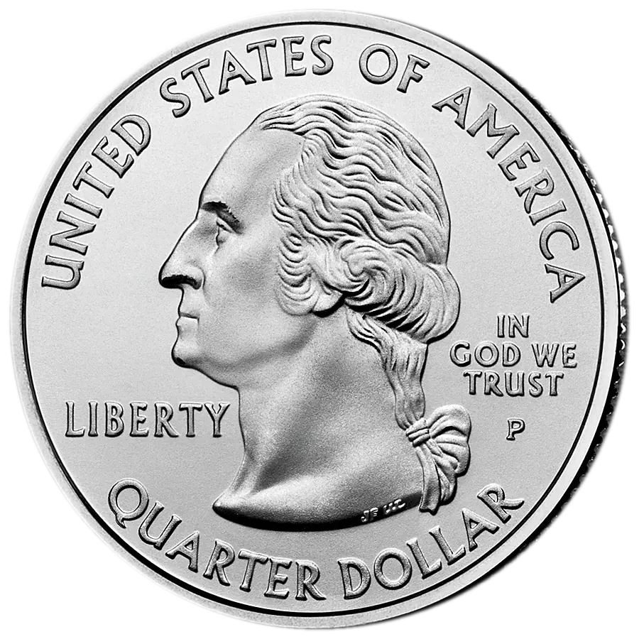
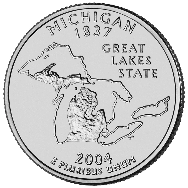
Exact Michigan reverse from the U.S. Mint; shared program obverse.
26 / 50release order
4mint/finish issues
P · D · Smint marks
2004release year
Story in 30 Seconds
The reverse shows a textured outline of Michigan’s Upper and Lower Peninsulas within outlines of Lakes Superior, Michigan, Huron, Erie, and Ontario. GREAT LAKES STATE is an actual inscription, not merely an editorial nickname.
Michigan borders Superior, Michigan, Huron, and Erie. Including all five connected lakes presents a regional system rather than claiming that Michigan borders Lake Ontario.
Governor John Engler created a 25-member Michigan Quarter Commission. More than 4,300 resident suggestions became five concepts sent to the Mint; after federal review and commission consultation, Governor Jennifer Granholm selected the state-outline-and-lakes design in September 2003.
Collectors should distinguish P and D circulation strikes, S clad proof, and S 90% silver proof. Peninsula edges, lake channels, fine map texture, inscriptions, and DW initials are the principal diagnostic zones.
Public Law 105-124 ordered state reverses by constitutional ratification or admission. Michigan entered the Union on January 26, 1837 as the twenty-sixth state, so its quarter became the program’s twenty-sixth coin and first 2004 release. One small reverse could not represent Anishinaabe nations, the fur trade, statehood disputes, mining, lumber, agriculture, automobiles, labor, migration, cities, civil rights, music, or every community. The selected design instead makes Michigan’s most recognizable geographic relationship—the state shaped and connected by Great Lakes water—the organizing identity.
Michigan consists of two major peninsulas between Great Lakes waters and borders four of the five lakes—Superior, Michigan, Huron, and Erie. Lake Ontario appears because the design maps the complete connected Great Lakes system. Water routes shaped Indigenous life long before statehood and later transportation, industry, settlement, recreation, and environmental policy. The coin communicates this geographic dependence clearly, while omitting the people, treaties, infrastructure, pollution, restoration, and cross-border governance that make the relationship historical rather than purely scenic.
The reverse’s central fact is adjacency: textured land is legible because smooth lake shapes surround it. The Lower Peninsula’s mitten and the Upper Peninsula’s long arc create a distinctive state silhouette without a landmark, portrait, animal, or manufactured object.
All five Great Lakes appear as one connected system. Official language emphasizes that Michigan borders four—more than any other state. Lake Ontario’s inclusion completes the system; it does not create a fifth Michigan shoreline.
GREAT LAKES STATE turns the map into an identity claim. The lakes shaped transportation, industry, settlement, recreation, and the state’s continuing water responsibilities. A map can suggest permanence, but lake ecology, shorelines, water levels, uses, and governance change over time.
World Coin Book reads the dark textured state against open lake fields as a figure-ground lesson: water does not decorate Michigan but visually defines it. That is editorial interpretation, not a separate Mint symbolic formula.
The design’s clarity comes through omission. Automobiles, the Mackinac Bridge, agriculture, Indigenous histories, labor, cities, and cultural life were available subjects but absent from the issued coin. Michigan chose a shared geographic frame broad enough to imply many stories without depicting them.
Governor John Engler created the Michigan Quarter Commission in 2001 as an advisory body within the Department of History, Arts, and Libraries. Contemporary institutional reporting describes 25 members drawn from education, art, history, numismatics, public life, business, and other fields.
Michigan residents submitted more than 4,300 design suggestions. The commission narrowed them to five concepts approved by Engler and forwarded to the Mint in May 2002. The five all used the Michigan outline but paired it with different combinations of the Great Lakes, state icons, Mackinac Bridge, and automobile.
The Mint converted concepts into candidate coin designs. Its contemporary account says the Commission of Fine Arts and Citizens Coinage Advisory Committee reviewed them and the Secretary of the Treasury approved them before their return to Michigan; CFA minutes show one June 19, 2003 review was postponed. Reviewed records do not preserve the complete model, comment, revision, and meeting sequence.
Public participation included the original statewide solicitation and informal opinion polling on the five candidates. The poll was advisory, not a documented binding statewide vote. After consulting the Michigan Quarter Commission, Governor Jennifer Granholm selected the Michigan outline with the Great Lakes in September 2003.
The Mint credits Donna Weaver as reverse designer and sculptor of the issued coin. That official credit distinguishes the commission’s concept-development role and resident suggestions from Weaver’s production-ready map, texture, inscriptions, and relief.
Procedures varied by state and changed during the program; each researched state page must document its actual path.
Alternative Designs
Five documented concepts all centered the state outline: (1) Michigan outline with Great Lakes; (2) outline with Great Lakes and state icons; (3) outline with Great Lakes and Mackinac Bridge; (4) outline with Mackinac Bridge and automobile; and (5) outline with Great Lakes and automobile. Reviewed official records do not preserve every icon, layout, model, artist, poll total, or revision, so World Coin Book describes the subjects without reconstructing missing candidate art.
The two main landforms that make the state outline distinctive.
Michigan Quarter Commission
Twenty-five-member advisory body that reviewed public suggestions and concepts.
John Engler and Jennifer Granholm
Engler created the commission; Granholm made the final state recommendation.
Donna Weaver
U.S. Mint artist credited with reverse design and sculpting.
Focused Timeline
Statehood
Commission created
Five concepts forwarded
Federal and state review
Release
Commission completed
Official Explanation and Interpretation
Artists and relief
John Flanagan’s Washington portrait, adapted by William Cousins, appears on the shared obverse. The citizen-suggestion and Michigan Quarter Commission process developed five thematic briefs, but reviewed evidence does not identify one citizen as designer of the issued map. The Mint credits Donna Weaver as reverse designer and sculptor. She translated the selected geography into shallow relief, choosing map contours, contrasting texture, channels, inscription placement, and readable spacing at quarter scale. CFA minutes confirm federal review activity, but the complete model sequence and production changes remain unavailable.
P and D are circulation issues. Both S issues were sold in proof products; the silver proof is a distinct 90% silver composition. Mintages are established catalog figures retained with an explicit source-audit limit.
Identification Guide
Identify the reverse by Michigan’s two textured peninsulas inside all five Great Lakes and GREAT LAKES STATE. P, D, or S appears on the obverse right of Washington’s hair ribbon. P and D are circulation strikes; S coins are proofs. A clad proof usually shows a copper-colored edge core and weighs 5.67 g; the 90% silver proof lacks that stripe and weighs about 6.25 g.
Condition Guide
Inspect peninsula tips and shore edges, the Upper Peninsula texture, narrow lake channels, small Erie and Ontario outlines, GREAT LAKES STATE, dates, motto, and DW. First wear dulls exposed land texture and lettering and interrupts luster. Narrow channels or map edges may be weak yet lustrous from strike or die state rather than wear.
Broad lake fields reveal contact marks, scrapes, residue, and cleaning; dense state texture can hide impacts. Check proofs for hairlines, haze, spots, fingerprints, frost breaks, and reduced cameo. Compare normal examples before calling a missing island, channel, shoreline, letter, or texture patch a filled die or struck-through error.
Mint Errors vs. Damage
Recognized catalog varieties: none are listed in current World Coin Book Michigan issue records. This evidence boundary does not prove no minor die varieties exist.
Genuine mint errors can include off-center strikes, broadstrikes, clips, wrong planchets, struck-through material, retained cuds, or substantial die cracks. Attribution requires correct metal flow, weight, geometry, and repeatable evidence.
An extra island or peninsula, doubled shoreline or GREAT LAKES STATE, missing lake, joined channel, detached Upper Peninsula, altered DW, or supposed Lake Ontario border is not rare by appearance alone. Mechanical doubling, die deterioration, grease, weak strike, glare, compression, wear, and impacts alter shallow map details.
Scratches mistaken for shorelines, dents mistaken for lakes or islands, cuts, flattened rims, dryer damage, corrosion, glue, plating, polishing, and heat color are post-mint damage. Michigan borders four Great Lakes, not all five; Lake Ontario appears because the coin shows the full system. The textured shape is not a forest inventory, satellite image, county map, or claim that shorelines never change.
Why Collectors Care
Durable value tiers
Worn P and D examples usually occupy the face-value design-set tier. Better circulation coins attract interest through full luster, clean lake fields, complete peninsula texture, crisp shorelines and channels, clear small-lake outlines, sharp inscriptions, and visible DW. Clad proofs form a collector-product tier; silver proofs add 90% silver as a separate composition tier. Geographic popularity adds interest, not automatic rarity. World Coin Book gives no live price promise: compare dated references for exact mint, finish, grade, strike, and surfaces.
Official law and U.S. Mint records establish program facts and image identity. World Coin Book separates official explanation, historical analysis, and editorial interpretation.
Official descriptions, historical context, and World Coin Book interpretation are labeled separately. No live prices are asserted. Last verified:
Reviewed official online records do not preserve Executive Order 2001-4’s full text, the complete 25-member roster, appointments, meetings, minutes, scoring, conflict controls, or the commission’s final report.
The complete 4,300-plus suggestion corpus, submitter demographics, eligibility rules, preservation location, and exact reduction method were not located online.
The five concepts are documented by subject, but reviewed primary records do not reproduce every state brief, Mint model, artist assignment, or layout.
The informal poll’s dates, sample, channels, question wording, controls, totals, rankings, and influence on the commission recommendation remain unresolved; it was not a binding statewide vote.
The full Mint feasibility, model, CFA and other advisory review, state-feedback, governor-recommendation, Treasury-approval, inscription, die, and production-change trail remains incomplete; CFA records one postponed review.
Reviewed evidence does not identify a citizen designer for the issued map or document every change from the five thematic concepts to Donna Weaver’s relief.
No official source assigns separate meaning to every island, channel, texture mark, shoreline segment, lake spacing, or exact cartographic projection.
Normalized mintages remain established catalog figures; future work should attach direct Mint annual-production and proof-sales evidence.